Dynamical Meteorology and Climatology Unit
ROADMAP (2021-2024, past project)
Weather and climate variability at mid-latitudes is largely controlled by variations in the atmospheric jet streams and associated storm tracks, which in turn are influenced by the underlying oceans. Atmosphere-ocean interactions have a large influence on our climate and societies.
The aim of ROADMAP ('Role of ocean dynamics and Ocean-Atmosphere interactions in Driving cliMAte variations and future Projections of impact-relevant extreme events') was to strengthen our understanding of the influence of North Atlantic and North Pacific ocean surface variability on the extratropical atmospheric circulation, with a focus on high-impact weather and climate extremes under present-day and future climate conditions. ROADMAP was a JPI-Oceans / JPI-Climate project that encompasses leading climate research institutions from seven European countries, including universities as well as institutions providing (national) meteorological and climate services.
Specific research topic at RMIB: Inference of dynamical links between different components of the climate system
The low-frequency variability and the interactions between the different components of the climate system cover a wide range of time scales from seasonal to multi-decadal. The understanding of these interactions is complicated by the limited time period of available observations. At the same time, climate models often do not agree on the amplitude of the variability in the different components of the climate system. These facts call for intensive empirical analyses of the coupling between these components (atmosphere, ocean, sea ice) in space and time.
Advanced analysis techniques based on dynamical systems and information theory were used to clarify the key spatio-temporal variability patterns in both the ocean and the atmosphere, and the interactions between the two components. These methods were used with observations, reanalyses, global climate models and intermediate-order ocean-atmosphere models.
An example of application in the framework of ROADMAP is the investigation of causal links between Arctic sea ice and its potential drivers (air and sea surface temperature, ocean heat transport, etc.) using the Liang-Kleeman rate of information transfer (see also Tools here). You can find more details about this study here.
In another study, we analyzed ocean-atmosphere interactions using satellite observations based on the rate of information transfer. The figure below shows that changes in sea-surface temperature (SST) cause changes in atmospheric turbulent heat flux (THF) in many regions of the world, including strong boundary currents and equatorial regions, and that changes in THF also cause changes in SST in eastern tropical Pacific and Atlantic regions (bottom panel). More details about this study can be found here.
In the framework of ROADMAP, we also compared the Liang-Kleeman information flow method to another causal method (PCMCI) as well as to correlation (see this study). As the method assumes linearity, Pires et al. (2024), with whom we collaborated, have developed a nonlinear extension of the approach. This nonlinear approach has been further applied to a reduced-order atmospheric model (this study).
At RMIB, the research was supported by the Belgian Federal Science Policy Office (BELSPO) under contract B2/20E/P1/ROADMAP.
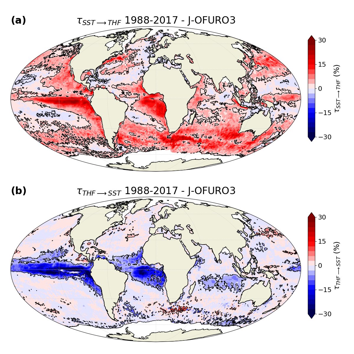
Rate of information transfer from sea-surface temperature (SST) to turbulent heat flux (THF) (top panel) and from THF to SST (bottom panel) using J-OFURO3 satellite observations over the period 1988-2017 (Fig. 4 of Docquier et al. [2023, https://doi.org/10.5194/esd-14-577-2023])
More information:
Dr. David Docquier, postdoc at RMIB
Dr. Stéphane Vannitsem, supervisor at RMIB